Bikeways in Columbus, Ohio and Vicinity Existing and proposed bikeway trails (Columbus Dispatch) 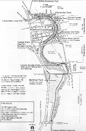  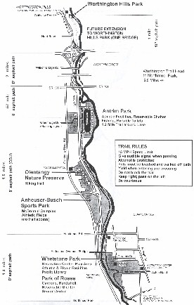 Map of Lower Scioto Trail, Lower Olentangy Trail, and Upper Olentangy Trail (Columbus Recreation & Parks). Click to enlarge.
As popular as bicycling has become as a form of recreation, commuter bicycling is still relatively uncommon because of the difficulties and problems involved, such as the lack of safe and convenient bike routes between residential and work environments. Surveys have been conducted by officials interested in creating alternative forms of transportation, including bicycling, as a way to reduce traffic congestion and atmospheric pollution. Responses from surveys can be used to plan potential bike routes and make improvements to existing routes in an effort to increase ridership. The survey data can also be used to predict ridership and potential traffic reduction and smog reduction from increased ridership. The purpose of my observations is to characterize and classify the trails so that conclusions can be made for improvements in trail quality. For a bikeway to be successful, there must be a close attention to the details.
The trail surface varies from asphalt to concrete sidewalks. Speed limit signs of 15 mph are posted because there are older sections of the trail that are bumpy, narrow, and have sharp turns. The nice thing about the Scioto-Olentangy trail is that it follows the rivers, which means there are fewer road crossings and it is more scenic. The northern section is more popular, especially at Antrim Park, because there are surrounding neighborhoods in close proximity, direct access from parking lots, and high visibility from State Route 315. The Olentangy-Scioto Trail consists of four segments, including the Lower Scioto Trail, the Spring-Sandusky Trail, and the upper and lower Olentangy Trail. The Olentangy-Scioto bikeway is the most aesthetically enjoyable trail in Columbus with its sweeping curves, ranging from the urban characteristics of downtown and OSU to the natural settings of the riparian canopy along the Olentangy River with views of the riparian corridors and changing scenery. Figure 1 illustrates the large and numerous trees along the bikeway at Whittier Peninsula, just south of downtown Columbus.  Figure 1. Scioto-Olentangy Trail at Whittier Peninsula (Brian). The Scioto-Olentangy Trail at Berliner Park is the most southern section of the bikeway. There are a lot of parking spaces at Berliner Park, but there are not any paved paths connecting the bikeway to the parking lot. Berliner Park is most commonly used for softball, and one rarely comes here to park their car and unload their bike with the intent of going for a bike ride. This trail is more of an inner-urban bikeway that is typically accessed from German Village or the Brewery District for commuting or recreation. The bikeway then crosses the Scioto River on Greenlawn Avenue. Then the bike route turns onto Front Street and next onto Whittier Street until reaching the Lower Scioto Park, which includes a boat launch and parking lot. Fishermen are often seen on the side of the river here. Whittier peninsula is also a spectacular area for bird watchers to enjoy. Eventually, the trail opens up to Bicentennial Park. At this point, bicyclists continue along the sidewalk on Civic Center Drive. There is a sense that the trail has finished its job by bringing you downtown. There are no clear bike directions. The signage is tricky and its very easy to get lost. Perhaps the city did not provide a bikeway in this section in order to bring you closer to downtown so that a bicyclist could commute to work or explore the city. This section definitely provides better views of downtown than by the banks of the Scioto River. The grid of streets may pull you into the city, but if you continue on Civic Center Drive and just past Broad Street, the trail takes bicyclists down a series of ramps and closer to the river, which allows a closer glimpse of Santa Maria. Figure 2 shows the trail adjacent to the Scioto River and Santa Maria.  Figure 2. Olentangy-Scioto Trial at Santa Maria (Brian). The trail then continues to Confluence Park where there is a new pedestrian bridge crossing the Olentangy River. Figure 3 shows the postcard view of downtown from the pedestrian bridge crossing the Olentangy River and connecting to Confluence Park.  Figure 3. Pedestrian bridge crossing the Olentangy River (Brian). There is a plethora of combined sewer overflow (CSO) pipes, that distract from the enjoyment of nature along the paths. The presence of CSOs lead to visual and odor nuisances for bicyclists along this stretch of the path. There were some instances where the CSOs where more concealed by landscaping, making the ride more aesthetically pleasing. On the opposite side of the river, the bikeway continues along the new floodwall in Franklinton. The bikeway ends at Dodge Park on the south end and provides a series of overlooks for viewing wildlife along the river, including fish, frogs, ducks, geese, and other birds. Unfortunately, this section of the trail has been exposed to vandalism, graffiti, and broken glass which has reduced ridership. There are also more fishermen and homeless people that is characteristic to this section. Figure 4 shows the bikeway, concrete floodwall, and levee at Dodge Park.  Figure 4. Scioto-Olentangy Trial at Dodge Park (Brian). The trail continues to Genoa Park, which includes the new riverfront amphitheater at COSI. The bikeway continues past Veterans Memorial, and ends at Souder Avenue, where bicyclists must cross the Souder Avenue bridge if they wish to continue on the bikeway along State Route 33. Figure 5 shows the bikeway along State Route 33. The bikeway ends at the City of Columbus utility complexes across from the Dublin Road Water Treatment Plant. An extension of the bikeway is planned in the future from this point along the Scioto River westward to Grandview Avenue.  Figure 5. Bikeway along State Route 33 (Brian).
 Figure 6. Spring-Sandusky Trial along Olentangy River (Brian). A major drawback of the bikeway is the proximity to the Spring-Sandusky highway network to the bikeway. Bicyclists will be subjected to a high level of traffic noise and potential traffic hazards of State Route 315. The proximity from the highway to the bikeway does provide a lot of lighting on the bikeway. Figure 7 shows the network of highways the bikeway crosses under. There is a potential for the path to flood when there is a bikeway underpass, illustrated in Figure 8.  Figure 7. The Spring-Sandusky Trial under a network of highways (Brian).  Figure 8. Flooded Spring-Sandusky bikeway underpass (Brian). The path also passes through a tunnel along the Spring-Sandusky bikeway, as shown in Figure 9. Lights were installed inside the tunnel. Graffiti has become a problem in this section.  Figure 9. Spring-Sandusky Tunnel (Brian). The path goes under a railroad bridge as illustrated in Figure 10.  Figure 10. A train passes over the Spring-Sandusky Trial (Brian). At one point along the bikeway, there used to be a strong, unpleasant smell from AC Humko on the other side of the Olentangy River on Perry Street in Harrison West. The AC Humko plant has since been demolished, and replaced with Harrison Park residential development. The path then forces you to cross the Olentangy River on the Third Avenue bridge. Figure 11 shows a section of the bikeway that comes dangerously close to Olentangy River Road at Third Avenue. In this case, a guardrail or fence is necessary.  Figure 11. Olentangy River Road and the bikeway (Brian). The Harrison West section of the bikeway stretches from Third Avenue to King Avenue and is .75 miles long, eight-feet wide, and asphalt. The trail is situated between the Olentangy River and Battelle. Riders can choose between an upper path built on the levee, or a lower path on the river bank. Figure 12 shows the highways, signage, river, and pavement markings.  Figure 12. Bikeway next to highway and river with proper signage (Brian). Side By Side Park in Harrison West is a great place to rest. Then head toward the Univesity District. An overlook is accessible from the lower path offering nice views of the river and the dam which is adjacent to the overlook platform. There is a nice area to rest on a sandstone retaining wall along the bikeway in this section. The Ohio State University section is 1.5 miles, eight-feet wide, and asphalt stretching from King Avenue to Lane Avenue. This portion of the bikeway is straight and built on the levee. It is open and sunny and has unmarked bike lanes. Figure 13 illustrates the bikeway built on the levee.  Figure 13. OSU section of bikeway built on levee (Brian). Sections of the bikeway at OSU are overgrown and pavement is rough. The bikeway squeezes between AEP and overgrown vegetation as illustrated in Figure 14.  Figure 14. The bikeway is narrow and rough (Brian). The path goes by Drake Union and the Ohio Stadium. Picnic tables are available along the bike path where it passes Ohio Stadium. I observed and analyzed the conditions where the bikeway and roadways intersect because this is probably the most critical and dangerous aspect of biking. I surveyed the areas from State Route 33 to Lane Avenue. Table 1 illustrates whether the bikeway goes under or over a roadway, and the usage of curb cuts, crosswalks, and bollards. The results generally showed a trend that the newer bridges allowed bicyclists to ride under a bridge, and access the sidewalks along the road by ramps. Curb cuts, Crosswalks, and bollards should always be provided. Bollards were only used in the OSU section, but should always be used where unauthorized traffic could drive onto the path.
There is an incomplete section between Lane Avenue and Tuttle Park. That section is committed and will be designed and completed with the Lane Avenue Bridge (MORPC). The bikeway continues into an expanse of parkland, including Tuttle Park, the OSU Wetland Research Park, Clinton Como Park, Northmoor Park, Whetstone Park of Roses, Antrim Park, and Olentangy Parkland. Approximately 1.1 miles north of Wilson Bridge Road to Worthington Hills is scheduled for extension (MORPC).
 Figure 15. New rail station representing the past (Brian). There are plans for the trail to extend to Plain City, which would make it 7.5 miles. The Heritage Trail is a rail-trail. Rail-trails are multi-purpose public paths created from abandoned railroad corridors. The trail follows a former Conrail (Pennsylvania) line that is completely straight, giving somewhat of a monotonous ride. Few trees are present to provide shade along the route, unlike the Scioto-Olentangy trail. Heritage Trail has unmarked bike lanes, but it does have excellent signage, curb cuts, crosswalks, and bollards at road crossings. Figure 16 shows the trail has unmarked bike lanes. The vegetation is low and sparse, yet there is some wildlife sometimes seen along the trail.  Figure 16. Heritage Trial has unmarked bike lanes (Brian). Some landscaping and shelters have been installed. This new trail appears to be very popular. One can watch the transition from the small town atmosphere of Old Hilliard through the sprawl of housing as developers acquire agriculture fields in western Hilliard and Washington Township. The Heritage trail also has a few dangerous road crossings. Bikers must come to a complete stop and watch for traffic before proceeding.
 Figure 17. Bikeway doesn't line up and crosses road at an angle (Brian). This bikeway is very similar to the Heritage Trail, but the trees are much larger and more numerous. The lane markings, signage, curb cuts, crosswalks, and removable bollards are present in this bikeway. Figure 18 illustrates the superb bikeway crossing at Countyline Road in Westerville.  Figure 18. Westerville bikeway crossing at Countyline Road (Brian). Bikeway planners must collaborate with different jurisdictions, such as the state, county, city, and townships in order for a project to succeed. A bikeway almost always crosses political boundaries, making projects take longer than usual. Table 2 illustrates the agency responsible for each project and the mileage. Funding and collaboration often involves several agencies.
Successful bikeways must exhibit a strong attention to detail. For instance, curb cuts, bollards, and crosswalks should be made at road crossings; water drainage from overhead bridges should not drain onto the bikeway; water must drain away from the bikeway; proper signage, bike lane markings, and centerline striping should inform the bicyclists and motorists; vegetation should be trimmed away from the trail; fences should be used when there are sharp turns, steep slopes, or other hazards; parking and access to the trail is necessary; and lighting is necessary in bikeway tunnelsand perhaps along the entire path. These issues are necessary to protect the bicyclists safety and are directly related to the publics health, safety, and welfare. The absence of these basic elements may result in a tragedy. Figure 19 shows a curb cut and crosswalk at a street level crossing. Figure 20 shows the problem of having no curb cut at a street-level crossing. A bicyclists would have to stop and lift their bike over the curb, perhaps with oncoming traffic.  Figure 19. Curb cut and crosswalk provided at King Avenue (Brian).  Figure 20. 5th Avenue problem of having no curb cut or crosswalk (Brian). Special adaptations may need to be made, such as cases where water from a bridge drains onto the bikeway. Figure 21 shows the gutter at Third Avenue that drains water from State Route 315 away from the Olentangy-Scioto Trail.  Figure 21. Gutter drains water away from bikeway (Brian). Successful bikeways also depend on other things, such as amenities. Availability of bike racks, water fountains, and places to stop for a rest create a more enjoyable experience. The presence of scenic views and a variety of settings, which the Scioto-Olentangy bikeway exhibits, adds interest for its users. Safety is also a concern to be addressed for successful bikeways. Safety concerns range from interaction with vehicular traffic to encounters with dogs and wild animals to competition between a variety of bikeway users such as joggers, roller bladers, walkers, and bicyclists. Bikeways may also be located along high-crime neighborhoods. Maintenance is also an issue which can factor into the success of a bikeway. Trails must be kept trimmed to prevent encroachment by adjacent vegetation. The bikeway will need occasional patch work or resurfacing. Signs may need replacement and curb cuts may need repair. Finally, and perhaps most importantly, successful bikeways form connections between destinations. Connections with urban neighborhoods, work places, and recreational activities lend practical value and purpose to the recreational aspects of the bikeway. Connections also increase bikeway accessibility and convenience. The trend suggests that the newer vehicular bridges allow bicyclists to ride under or over bridges, keeping vehicular and non-motorized traffic separate. This creates greater continuity in the bikeway. However, there is a potential for the low-lying portions of a bikeway under bridges to occasionally flood. Since the bikeway serves as a commuting route for some users, it is beneficial to provide multiple connectors in the event one is flooded. There are several ways a bikeway may cross a roadway. These include a crosswalk at street level, an overhead pedestrian bridge, and underpass, a tunnel, or a combination street level crosswalk and bike path underpass. Each of these options has both advantages and disadvantages, which are presented in Table 3.
Bikeways must address an array of concerns. Those who are planning bikeways should look at the successes and failures of existing bikeways. The character of the Olentangy-Scioto Trail, the Heritage Trail, and the Westerville Bikeway will vary, providing choice and interest for its users. Certain basic elements must be provided, such as adequate bikeway crossings, signage, and bike lane markings. Planners will certainly need to look at the long range plans and collaborate with many different agencies.
The Columbus Dispatch. Local bicyclists peddle idea of preserving Rt. 315 bridge. Brian Williams. May 4, 2000. (www.dispatch.com). Columbus Recreation & Parks. Cycling Ohios Trails and Bikeways (richnet.net/~bikeohio/). Mid Ohio Regional Planning Commission. (http://www.morpc.org). Ohio Department of Transportation (www.dot.state.oh.us/bike/). Olentangy-Scioto Bikeway (www.intellweb.com/trails/olentan.htm). Rails-to-Trails Conservancy. (http://www.railtrails.org). Richardson, Shawn. Biking Ohios Rail-Trails. Adventure Publications, Inc, Cambridge, MN. 1996. Ryan, Karen. 40 Great Rail-Trails in the Mid-Atlantic. Rails-to-Trails Conservancy. |
||||||||||||||||||||||||||||||||||||||||||||||||||||||||||||||||||||||||||||||||||||||||||||||||||||||||||||||||||||||||||||||||||||||||||||||||||||||||